A road will be closed, bike lanes will be built, a bus will be rerouted and a bus stop will be placed on an island – these are just some of the changes being contemplated in the downtown plan.
The downtown transportation plan is nearing the finish line after more than two years of work. Staff provided council with an overview of the plan at the June 22 meeting and is expected to present it to council on July 13.
Mayor Jonathan Cote said the downtown core is the leading area when it comes to transportation, but the design of the road network in that neighbourhood doesn’t reflect today’s downtown.
“I think the plan is an important step, but I guess what I am more excited about is actually starting to operationalize and implement some of key concepts. … I think what this plan really does is actually better connect that neighbourhood where it is and where it is going in terms of transportation compared to some of its past designs,” he said. “I am really eager to see us work through that process and actually see some of these big steps and big moves start to be implemented.”
Big changes coming
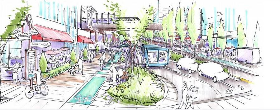
A recent staff presentation included artist’s renderings about some components of the plan, including the Eighth Street "complete street" – an area close to the New Westminster SkyTrain Station and Anvil Centre.
While walking, cycling and transit are dominant modes of transportation on Eighth Street, primarily between Carnarvon and Columbia, but also between Carnarvon and Royal, the street doesn’t look anything like how it currently functions, said Lisa Leblanc, the city’s transportation manager.
“When you look at the proportion of road width that’s given over to walking and cycling, it doesn’t reflect that dominant mode,” she said. “So what we are proposing is a reallocation of space on Eighth Street to better reflect what’s actually happening today, and to better support ongoing increases in sustainable modes on Eighth Street and across Eighth Street.”
The vision includes a weather-protected, mid-block crossing (where many people already cross) under the SkyTrain guideway on Eighth Street, a centre median, wider sidewalks, fully separated cycling lanes on both sides of the street from Royal to Columbia, and greening of the space.
“We see it as entirely possible to implement an interim treatment using flexible bollards and pavement markings, planter boxes, that type of thing, in order to establish this vision in a temporary or a quick-build kind of way,” Leblanc said.
Leblanc said it’s envisioned that the bus shelter on Eighth Street (near the SkyTrain station) would eventually be placed on “a bus island” to better serve people walking on this sidewalk, as well as people who are boarding and alighting from the bus. While it could take some time to build the bus island, other changes could happen quite soon.
“In the long-term, we see the bus shelter on a bus island. We see that empty lot being redeveloped into something that’s much friendlier on the street,” she said of a site at the foot of Eighth Street. “We see the centre median, with single-lane traffic in each direction. We can see this being implemented as an interim measure within the next six to 12 months, with pavement markings and flexible bollards, and a temporary, quick-build bus bulge, to at least get the boarding and alighting off of the sidewalk.”
What’s happening on Carnarvon?
The city believes current and future developments on Carnarvon Street will help it become more of a complete street and create opportunities to improve connections along the street to the Shops at New West and to the New Westminster SkyTrain station.
“Carnarvon has a great opportunity to become a complete street,” Leblanc said. “There are existing problems with Carnarvon Street. There is a lot of people queuing and waiting on a very narrow, obstructed sidewalk.”
The downtown transportation plan anticipates an expansion of the bike network on Carnarvon Street. Road options include making Carnarvon Street one-way eastbound in order to provide more space adjacent to curbs for people waiting to board buses, or keeping it as a two-way street but removing some parking on the north side of the street.
“Ultimately, this is how we envision Carnarvon Street, with single-lane traffic in each direction, buses continuing to pull up to the curb, more space for people on sidewalks, and a bike lane heading westbound on Carnarvon Street on the north side of the street,” Leblanc said.
Key directions in the plan
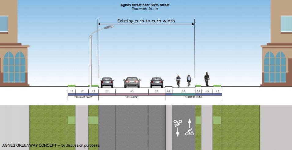
Eighth Street and Carnarvon Street are just two pieces of the downtown transportation plan, with other key directions including the use of SkyTrain stations as multi-modal hubs prioritizing sustainable modes of transportation, construction of the Agnes Greenway and the development of a cycling network. A comprehensive network of primary and secondary cycling routes is planned throughout the downtown.
Leblanc said the primary network would be constructed to AAA standards, which almost always means separated bike lanes for all or some segments of the route. The seconday bike route would primarily be implemented with signage and pavement markings.
“So it’s not quite the same level of service as a AAA facility, but a much more extensive and direct network of bike lanes that will be signed so it draws motorists’ attention to the fact that they should be expecting cyclists on these routes,” Leblanc said. “It will result in 30-kilometres-per-hour speed limits on these streets. It also helps with cycling way-finding to key destinations in the downtown and outside of the downtown. There’s about five kilometres of secondary route in the downtown, so it is not an insignificant amount of bikeway.”
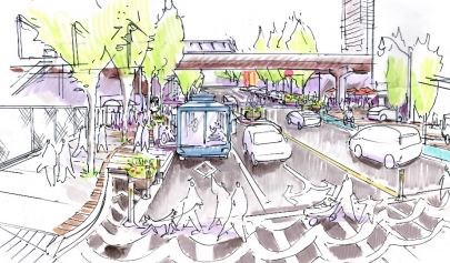
Greening of Agnes Street
The future Agnes Greenway is primarily on Agnes Street, but it connects to Carnarvon and Begbie streets, which are viewed as links to key destinations, like the New Westminster SkyTrain station and the riverfront. The greenway envisions separated bike lanes on the south side of Agnes Street, greenway improvements that will be unique to each block, potential tree plantings on private property and more.
“Implementation of this greenway will require some traffic changes within the neighbourhood,” Leblanc said. “Some of them will feel significant to some people.”
According to Leblanc, the Agnes Greenway requires three segments of one-way streets: Agnes Street between Merivale Street and Fourth Street will require a one-way segment westbound; Agnes Street between Sixth Street and Fourth Street will require a one-way segment eastbound; and Fourth Street will be one-way southbound between Agnes Street and Carnarvon Street.
“We are also proposing a road closure in support of this greenway, which is a small piece of Merivale, the slip ring that comes off of Royal Avenue eastbound,” she said. “We are proposing to close that to enable extension of this existing multi-use path that connects into an already-good crossing across Royal Avenue at Third Street and into an excellent bike connection into Tipperary Park, which forms an important connection up to uptown from downtown.”
Buses will also have to be rerouted in order to accomplish the goals of the greenway, Leblanc noted, so the city has already engaged TransLink and Coast Mountain Bus Company in that discussion. It’s yet to be determined whether the bus will be rerouted to Merivale Street or Elliot Street.
“We see us constructing this in two phases, beginning with Phase 1 potentially as early as 2021, subject to funding,” Leblanc said of the Agnes Greenway. “If we can get the funding in place, we would advance this. Otherwise, it would be completed in the current five-year plan. Phase 2 would be completed over a number of years, elements of it through redevelopment of adjacent properties and through future capital plans, with elements of it being implemented, such as signage and pavement markings, in the interim so that we do have a complete route signed to the SkyTrain station and to the riverfront. It just wouldn’t be in its final constructed form for a number of years.”
Curb changes coming
Another one of the key items in the downtown transportation plan is a plan to prioritize curb space to support priority modes and a quality, people-centred public realm.
“This is easily the most challenging piece of the plan to communicate our intentions with respect to curb space,” Leblanc said. “Curb space refers to, typically, to what people think about first with curb space is parking or bus stops, but there’s a lot more going on at the curb than parking and bus stops. There are also deliveries. There are also opportunities for parklets and for greening. There are also opportunities to improve access for people with disabilities. Loading and servicing. And it goes on.”
According to a staff report, curbside space in urban areas is important for many reasons and is “valuable for much more than the storage of private vehicles.”
“It’s quite a challenging thing to talk to people about the curbside space and prioritization of this space because everybody feels a piece of ownership about the curb,” Leblanc said.
A set of guiding principles outlines the city’s priorities for curb space, with sustainable transportation (including sidewalks, bike lanes, transit and bike parking) being the Number 1 priority. That’s followed by: Number 2 – access for people (including accessible parking, bus stops, passenger zones); Number 3 – greening and activation (plantings, street trees, parklets, patios, food trucks); Number 4 – delivery and loading (local and commercial deliveries); Number 5 – short-term parking (car share, visitor parking, servicing, meter parking); and Number 6 – on-street parking.
“On-street parking becomes a lower priority,” Leblanc said. “The reality is some space on-street curbside for parking of private vehicles, in particular, will be reduced.”
Coun. Patrick Johnstone said the development of principles related to the use of curbs is important work.
“It’s good that we have some policy guidance,” he said. “I think curb space ends up always being that point of tension when we are redefining road spaces, especially in a downtown area.”
Rerouting the 106 bus
The engineering department is also proposing that the 106 bus be rerouted eastbound on to Carnarvon Street, as the city believes it will improve bus speed and reliability – and allow for the creation of an accessible bus stop with weather protection and seating on Sixth Street, just north of Carnarvon Street.
What about roads?
The road network won’t be forgotten in the downtown transportation plan, said Leblanc, but it’s definitely not being prioritized as high as sustainable modes of transportation.
A staff report states there are “numerous” streets throughout the downtown area that are wider than necessary. Over time, the city will be able to reallocate “excess pavement” for other priority uses.
“We anticipate right-sizing of roads through reallocation of excess pavement. There are streets that have too much pavement for what’s required,” Leblanc said. “We see opportunities for urban forest and integrated storm water management, parklets and park streets.”
The city also wants to use way-finding signage, signal-timing optimization and informational signage at “decision” points for drivers to ensure traffic goes where it’s supposed to be.
“We want to see the right traffic on the right road and discourage shortcutting through local roads,” Leblanc said.
What’s the plan for the plan?
Once approved by council, staff anticipates it will take several years to implement the downtown transportation plan – as some of it will take place as adjacent properties are redeveloped. Initiatives will be done in phases: Immediate – within a few months; near term – within six to 12 months; medium term – within the city’s current five-year financial plan; longer term – five to 10 years; and much longer term – through development and/or with significant partnerships.
“Some measures will be implemented in the very near-term. Some already have been,” Leblanc said. “In the near-term, we anticipate having a signed downtown/uptown cycling route. We anticipate having Carnarvon Street, the widening of the sidewalk on the south side taken care of. We are (closing) Front Street on weekends throughout the summer to enable connections between Westminster Pier Park and Sapperton Landing.”
Within six to 12 months, the city anticipates having signage, pavement markings and quick-build calming traffic circulation changes and interim separated bike lanes on the Agnes Greenway.
“We also anticipate, in the immediate- and near-term, advancing quick-build designs for the Agnes Greenway and advancing the detailed design so that it’s ready for construction in 2021 if we get external funding to support that,” Leblanc said. “We also propose implementing the secondary bike network within the next year, having signage and pavement markings in place.”
Staff is also working on plans and designs regarding some quick-build basic elements of the Eighth Street Complete Street section south of Carnarvon Street, including improvements to the bus stop.


